1. Click the Tools button and select Measurement.
The Measurement
Tools window appears.
You can measure the distance along a path on the map.
1. Click the Tools button and select Measurement.
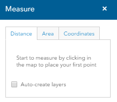
The Measurement
Tools window appears.
2. Click the Distance tab.
Tip - Click the Auto-create layers checkbox to automatically add measurements you create to a drawing layer.
3. Click on the map to select a start point.
4. Move the mouse to a second point and click.
5. Continue to select points to draw and define the path to be measured.
6. Double click to select an end point. (The illustration below depicts a sample path.)
7. The Measurement Result section displays the total distance of the path.